
Use slider bar above to explore an example of a shaded fuelbreak, before and after treatment
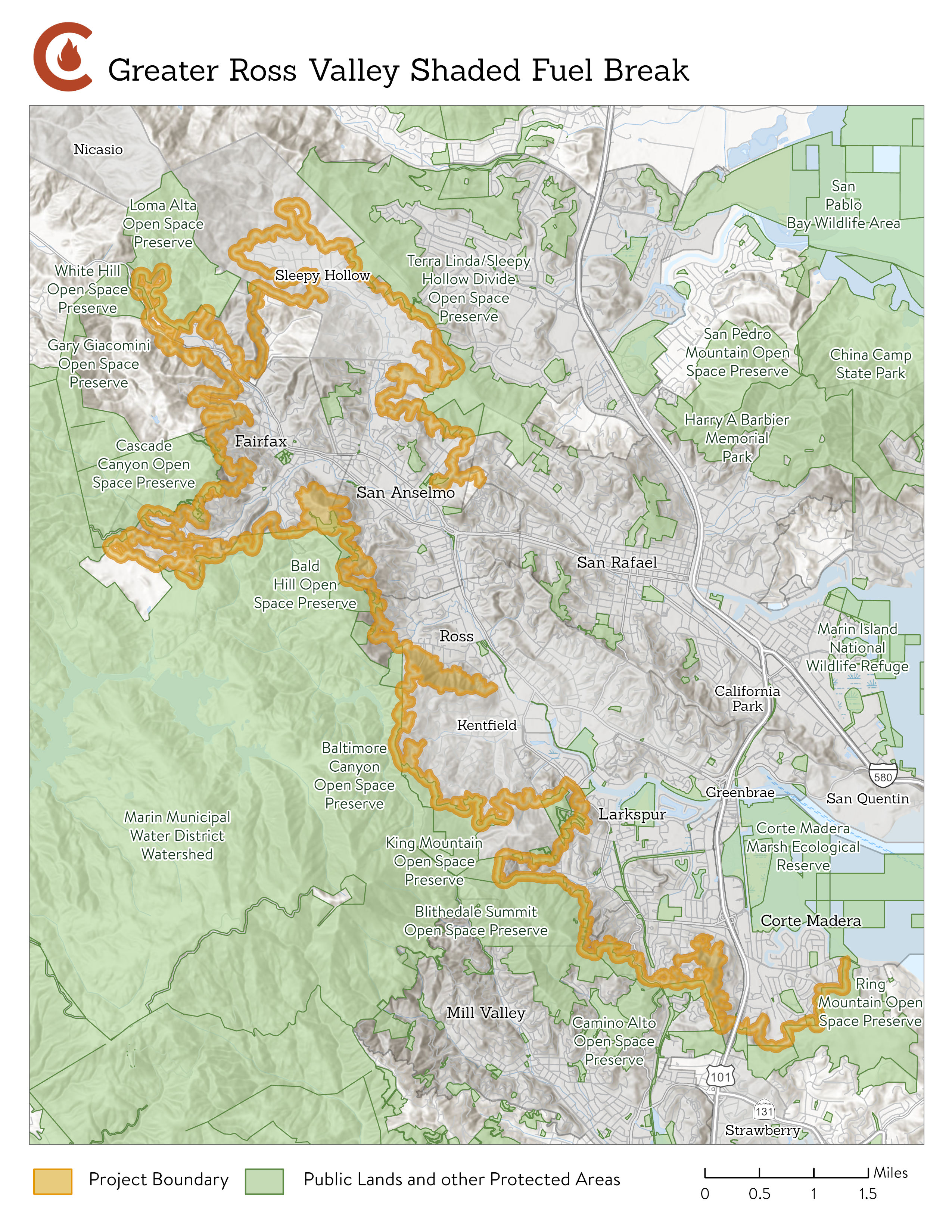
The Greater Ross Valley Shaded Fuel Break (GRVSFB) is a 38-mile shaded fuel break creates defensible space adjacent to approximately 2,000 parcels in Central Marin. The fuel reduction zone includes up to 1,800 acres in unincorporated Marin County, the City of Larkspur, City of Mill Valley, Town of Fairfax, Town of Ross, Town of Corte Madera, Town of San Anselmo, and Kentfield. The project is designed to slow the spread of wildfire to give firefighters time and space to suppress flames before a fire would enter the built environment. This project reduces fire risk to several communities in the wildland urban interface (WUI) while improving forest and ecosystem health by reducing non-native plant cover. The Greater Ross Valley Shaded Fuel Break is a collaboration of Marin Wildfire, Marin County Fire Department, Ross Valley Fire Department, Kentfield Fire Protection District, and Central Marin Fire Department. This project is funded by Measure C (Marin Wildfire Prevention Authority), Measure A (Marin County Parks) nd a generous grant through the California Department of Forestry and Fire Protection’s (CAL FIRE) Wildfire Prevention Grant Program.
Project activities focus on thinning understory vegetation near homes and roads, including removal of nonnative, invasive French broom; dead woody debris; and pruning bottom branches of trees. Most trees remain in place.
Want to learn more?
Check out our Frequently Asked Questions (FAQ) document HERE.
Check out project photos HERE.
Learn how French broom removal improves wildlife habitat HERE.
RESIDENT RESOURCES: Have you been contacted about participating in this project? The Property Owner Right of Entry Form is intended to grant permission to MWPA employees, contractors, and partner agency employees to access private property while providing services as part of the GRVSFB project. If your property is located within the project area, you may have received this form in the mail. If so, please sign and return the form digitally by clicking "here", or mailing the hard copy to:
Attn: Steven Peters
Marin Wildfire Prevention Authority
1600 Los Gamos, Suite 345
San Rafael, CA 94903
If you have misplaced your hard copy you may print the online version or contact us to request another hard copy at grvsfb@marinwildfire.org or speters@marinwildfire.org.
Project Update, Spring/Summer 2026: Work will continue directly adjacent to homes and roads in the GRVSFB project area beginning August 3 to avoid the nesting bird season. Work will continue in Fairfax and Kentfield with plans to expand into Larkspur depending on available funds and access. Currently, crews are scheduled to begin in the Deer Park area of Fairfax and the Ridgecrest Rd area in Kentfield. Resources surveys were completed in spring 2026 ahead of work taking place. If you receive a request for access, please return your right-to-enter form as soon as possible to allow for access. An FAQ document is available HERE.
In 2026, the GRVSFB will include work along a number of roads, including the following:
Kentfield:
Fairfax:
Larkspur:
Project Update, Summer/Fall 2025: Hand crews started work August 4 to avoid the nesting bird season in the Fairfax and Kentfield areas. Work targeted nonnative invasive shrubs, dead and down woody debris, limbing up trees, etc.
In 2025, the GRVSFB included work adjacent to homes and roads. In Kentfield, work took place along the following roads in 2025:
In 2025, the GRVSFB included work adjacent to homes and roads in Fairfax as well, including the following roads:
Project Update, Spring/Summer 2025: Work will start up in August to avoid the nesting bird season and will continue in Fairfax and expand into the Kentfield area. Exact work locations will be determined by field surveys, right-to-enter documentation, access, and funding. If you receive a request for access, please return your right-to-enter form as soon as possible to allow for access. An FAQ document is available HERE.
Project Update, Fall 2024: Work continues by hand crews in the Cascade Canyon area. This critical and challenging work is actively removing nonnative invasive broom cover by hand on steep slopes next to homes. Photos of some of the work completed in 2024 are available HERE.
Project Update, Summer 2024: This season's project activities began on August 1, 2024. Crews will be active in the Cascade Canyon area (late summer and fall) and will move along the project area towards Bald Hill (fall and winter). THIS FIGURE shows upcoming work areas.
Project Update, Spring 2024: In year 1 (summer 2022 - Jan 2023) and year 2 (spring/summer 2023 - Dec 2023), approximately 20 miles of project area was completed. Crews will kick off year 3 starting August 1, 2024 and will continue to work in the Cascade Canyon area as well as the Sky Ranch and Bald Hill neighborhoods southward toward the Town of Ross. Please see THIS FIGURE showing project phases. Please note that this work spans both public and private properties. If you have received a right of entry form, your property may overlap this project area. If so, please make sure to return the right of entry form to Marin Wildfire by mail or submit it digitally using the link below.
This project is funded by Measure C and a generous grant through the California Department of Forestry and Fire Protection’s Wildfire Prevention Grant Program.
Would you like to learn more about how vegetation management helps reduce risk?
CLICK HERE to see recent case studies from CAL FIRE describing the role of vegetation management projects in recent fire suppression efforts.
CLICK HERE for a short video explaining how vegetation management alters wildfire behavior.
CLICK HERE for more resources on the science behind this work.
The following public events have occurred for the Greater Ross Valley Shaded Fuel Break Project. To receive info regarding future project meetings, please send an email to: GRVSFB@panoramaenv.com. Future public events for this project will also be advertised on this project webpage and included in the MWPA community calendar. Project neighbors will generally receive a mailed postcard advertising relevant public events in their area. Additionally, follow MWPA on Facebook, Twitter, and Instagram for the latest information and updates.
11/28/23 Site Visit: Approximately 30 people attended a site visit to the GRVSFB, focusing on the areas in and around the Cedars, which serves residents with developmental disabilities.
8/17/22 Site Visit: Approximately 50 people attended a site visit to the GRVSFB, focusing on the Terra Linda / Sleepy Hollow area.
7/26/22 Public Meeting: Sleepy Hollow Community Center, 6-7:30pm, with remote viewing option provided. At this meeting, residents and stakeholders learned about the first phases of project implementation. Presentations, posters, and handouts are posted below.
Presentation Video: Available here
Presentation Slides: Available here
Project Map Posters:
Poster 1: Overall Project Area
Poster 2: Phase 1 Project Area
Poster 3: CalVTP Process
Poster 4: Treatments within the Project Area
Project Summary Handout: Available here
3/10/22 Public Meeting: The MWPA and participating member agencies hosted an online public meeting via zoom on March 10, 2022 from 6-8pm to share information about the Greater Ross Valley Shaded Fuel Break Project.
Topics included:
• A description of the project and its goals and objectives
• Fuels management methods and monitoring
• California Vegetation Treatment Program (CalVTP) environmental review process
Breakout Room 1 Slides: Vegetation Treatments
Breakout Room 2 Slides: Methods and Modeling
Breakout Room 3 Slides: Environmental Resources and Compliance Process
Video: Main Presentation and Breakout Room 1 (all 3 sessions)
FAQs & Photo Examples
Frequently Asked Questions - 2025
Frequently Asked Questions - 2024
Frequently Asked Questions - 2022
Environmental Documents
The Greater Ross Valley Shaded Fuel Break Planning Project (GRVSFB) includes activities covered by CAL FIRE’s California Vegetation Treatment Program (CalVTP) Program Environmental Impact Report (PEIR). That analysis is available here: Project Specific Analysis (PSA)-Addendum
More Project Resources
Overall figure showing project phasing.
Draft Project Area Maps (updated 3/10/22)
To view the project area spatially, click on this link: Overview KMZ and download the file. This file is viewable using Google Earth and allows the user to navigate and zoom into different parts of the project area. Open the file with earth.google.com or install Google Earth - use these instructions.
Note: The KMZ file shows the shaded fuel break as 300 feet wide, although typically fuel and forest health restoration treatments would occur within a 200-foot-wide zone.
Summer and Fall 2024 work areas will include the Cascade Canyon and Deer Park areas of Fairfax. Please see this figure to view project phases. If you live in these areas and you haven't already done so, please submit a right-to-enter form through our project webpage above.
