

The San Rafael - San Anselmo Fuel Reduction Zone Project (formerly called the Ridgewood Shaded Fuel Break Project) is a joint project of the San Rafael and Central Marin Member Agencies and includes collaboration among several partners, including San Rafael Fire, Ross Valley Fire, Town of San Anselmo, Marin County Parks, the Tamalpais Cemetery, and others. The proposed project includes environmental compliance, planning, outreach, and the first phase of implementation of a fuel reduction zone between San Rafael and multiple Central Marin communities. Project activities of this multi-year project would be phased and would include thinning of nonnative invasive eucalyptus trees and restoration with native species with the purpose of reducing wildfire risk and intensity in a strategically important location.
SRSAFRZ Frequently Asked Questions (updated July 2026)
Before and After Photos (updated 7/31/25)
Acoustic Bird Monitoring (updated 9/24/25)
Project Update 3/30/26:
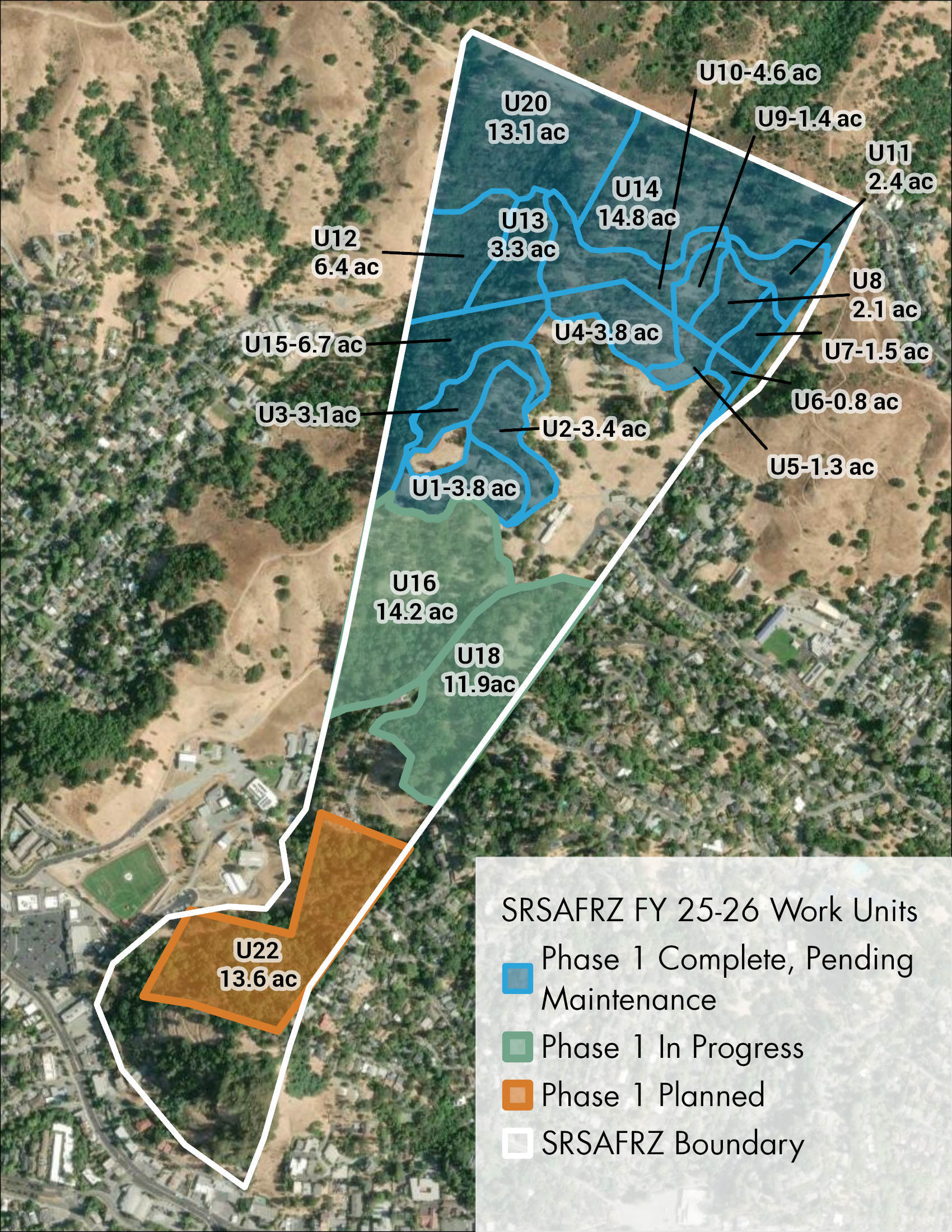
Initial treatments (Phase 1) are underway this spring in work units 12 &13 (see this project map) within Marin County Parks lands and unit 16 within the Tamalpais Cemetery. Phase 1 treatments that include removing all eucalyptus under 10" DBH and some selective removal of eucalyptus 10" to 15" DBH and incidental non-native tree species are planned to conclude by December 2026. Targeted herbicide application will occur in spring 2026 to address non-native shrub regrowth (French broom) regrowth and in fall 2026 to address eucalyptus regrowth. These maintenance treatments will occur in all units throughout the project where Phase 1 tree removal is complete. For work occurring between February and August, nesting bird surveys are conducted by qualified biologists every 7 days before the tree crews begin work. If nests are discovered by biologists or by the tree crews during work, the nests are appropriately flagged and avoided. For work that concludes in fall before the wet season, a qualified geologist will inspect erosion control mitigation measures and make recommendations for more if needed.
Project Update 10/30/25:
Treatments are ongoing in both untreated areas as well as areas that were initially treated last year, including limbing and vegetation thinning. Targeted herbicide application is occurring to treat eucalyptus and address eucalyptus regrowth.
Project Update 7/15/2025:
During the 2025/2026 fiscal year, eucalyptus thinning and broom removal will continue in the areas shown above in the figure in pink.
Project Update 4/7/25:
During the spring, summer, and fall of 2025, eucalyptus thinning and broom removal will continue in the Phase 2 work areas indicated HERE in green. These units will likely be completed in 2025. Additionally, data collection will continue in the pilot project area, including continuation of the herbicide study in collaboration with UC Cooperative Extension and FIRE Foundry.
Project Update 10/4/24:
Defensible Space Work - Eastern Edge (3.7 acres; red striped polygon in figure above): San Rafael Fire completed initial treatment of the defensible space areas near homes on the eastern edge of the site in August. This work generally included removal of broom and dead and down material as well as limbing up of trees and removal of a small number of eucalyptus trees.
Defensible Space Work - Cedars of Marin: Marin County Fire Department treated broom and limbed up trees around the Cedars of Marin in August. A small number of hazardous trees directly adjacent to buildings were also removed.
Eucalyptus Thinning, Phase 2 (17.9 acres; green polygon in the figure above): San Rafael Fire, Marin Wildfire, and Marin County Parks are actively coordinating work in this area, including Measure A funded work on several acres of parks lands. Broom removal began in September and eucalyptus thinning will begin by mid-October.
Eucalyptus Thinning, Phase 1 / Pilot Project Follow-up (up to 10 acres; blue polygon in the figure above): Initial treatment in the pilot project area was completed in June 2024. In September/October 2024, crews will revisit tree stumps and recut the stumps lower to the ground, cut back sprouts, and paint on herbicide (garlon 4). San Rafael Fire, Marin Wildfire, and UC Cooperative Extension are working on a study to compare the efficacy of different approaches to herbicide treatment.
Public Field Trip: Approximately 35-40 people attended a field trip on September 11 to view the next phase of work on the hillside east of the cemetery.
Project Update 8/16/24: Join us on September 11 at 10am for a public field trip to see the next phase of eucalyptus thinning! We'll meet at the Mt. Tamalpais Cemetery entrance at the end of Fifth Avenue in San Rafael. The postcard mailed to project area neighbors may be viewed HERE. Details below.
Project Update 8/1/24: THIS FIGURE shows where project activities are taking place in the summer, fall, and winter of 2024. Work includes defensible space work adjacent to homes on the eastern edge of the project area, follow-up work on eucalyptus stumps within the pilot project area, and work on the hillside to the east of Mt. Tamalpais Cemetery in partnership with Marin County Parks. Estimated timing of project activities may change based upon weather conditions (i.e., red flag warning days or precipitation).
Project Update 6/21/24: Treatment of the 10-acre pilot project area has been successfully completed. Large trees and native trees remain standing in the project area while eucalyptus trees 10 inches dbh and under (dbh = diameter at breast height, which is diameter at 4.3 ft above ground) and French broom have been removed. Planning for future phases is underway.
Project Update 5/6/24: Over 53 participants joined us at our public tour on Monday, May 6. Members of the public were able to watch project activities and hear about work done thus far and future phases. Activities in the pilot project area continue. Material is being chipped and left onsite. The few active bird nests in the area continue to be protected and avoided.
Project Update 4/26/24: Work continued within approximately the same footprint as last week. Approximately 4 acres are complete and 1.5-2 acres are in progress. Two bird nests were found to be under construction by wildlife biologists and no-work buffers were established. No work will take place near these nests while they remain active.
Project Update 4/19/24: Work continued within approximately the same footprint as last week. Approximately 6 acres are either complete or in progress within the pilot project area. No new bird nests were found by wildlife biologists this week.
Project Update 4/12/24: Work continues Monday through Friday as weather allows. Nesting bird surveys continue to be performed by wildlife biologists to ensure no work takes place near active nests. Approximately 2.4 acres have been completed and another 3.2 acres are in progress within the 10-acre pilot project area.
Project Update 3/26/24: In the map above, the 10-acre blue polygon depicts the 2024 "pilot project" - the first area to be treated in 2024. Work is currently underway (Mon-Fri as weather allows) within a 3.8-acre portion of the pilot project area. Work generally includes removal of small diameter eucalyptus trees and some larger diameter hazard trees where needed. A few small diameter native bay or other trees may be removed in some locations but most native trees will be retained. Please note that nesting bird surveys are taking place regularly to avoid work near active nests.
Photos: Before and After Photos (Updated 7/18/24)
More information is available here: Frequently Asked Questions (Updated 9/10/24)
Public Field Trip #4 (September 11, 2024)
Marin Wildfire, San Rafael Fire, Marin County Parks, the Ecologically Sound Practices Partnership, and other partners hosted a public site visit to see Phase 2 of the eucalyptus thinning. Approximately 35-40 people attended. This field trip was live streamed and is viewable HERE.
Public Field Trip #3 (May 6, 2024)
MWPA, San Rafael Fire, Ross Valley Fire, Town of San Anselmo, and the Ecologically Sound Practices Partnership hosted a public site visit to show areas treated thus far, watch project activities in real time, and ask questions. Approximately 53 people attended. This field trip was live streamed and the video is available HERE.
Public Field Trip #2 (February 13, 2024)
MWPA, San Rafael Fire, Ross Valley Fire, Town of San Anselmo, and the Ecologically Sound Practices Partnership hosted well over 50 attendees to hear about the first 10 acres of project implementation (the "pilot project"), planned for early 2024. The tour included an overview on the project planning process and next steps after the pilot is completed. This field trip was live streamed and the video is available HERE.
8/16/23 Public Meeting:
Thank you for joining us for a virtual presentation and Q&A session on August 16, 2023 from 6:00 to 7:30pm. If you missed the meeting, we invite you to watch the presentation and review the slides by following the links below.
Residents in the area received this meeting invitation in the mail.
Presentation Video: Available here
Presentation Slides: Available here
Public Field Trip #1 (August 29, 2023)
On August 29, 2023 neighbors and various stakeholders joined MWPA, San Rafael Fire, Ross Valley Fire, and MCOSD for a walk in the project area. Stay tuned for future opportunities to view project implementation activities.
Email questions to: srsafrz@panoramaenv.com
More Project Resources
Click here to view the map
To view the project area spatially, click on this link: Overview KMZ and download the file. This file is viewable using Google Earth and allows the user to navigate and zoom into different parts of the project area. Open the file with earth.google.com or install Google Earth - use these instructions.
